|
Corsica River Guide |
|
Corsica River Guide |
The Taravo and Rizzanese flow out of the lower granite ridges to the south east of Corsica. Consequently the effect of snowmelt is lessened (if not entirely absent) and the rivers will depend mainly on rainfall to determine the levels.
When deciding on a canoeing programme the two rivers are best thought about as one unit because of their geographical proximity. In that way good paddling can easily be found in the area whatever the water level. Low water will bring the Rizzanese and upper Taravo into play, whilst high levels will cause you to move further down the Taravo, or enjoy the scenic but easy waters of the lower Rizzanese.
| UPPER TARAVO | |
|---|---|
| From | Palneca |
| To | D757 Road Bridge |
| Grade | 3 then 5 (if final section portaged) |
| Length | 13 km |
The Taravo is much longer than the Rizzanese. It starts as a small mountain stream at the Col de Verde, less than a kilometre from the start of the Fium Orbo.
The highest practical start point is at the village of Palneca. The river is initially quite small, needing a reasonable amount of water in the valley to make it canoeable. The first obstacle to cross is the town dump, which impinges onto the river. Although the dump is soon passed it's effect can sadly be seen for the entire length of the river. Plastic bags, car tyres and bottles are trapped in the undergrowth on the bank for miles downstream.
The river soon grows in size as streams join from both sides. Initially it runs at grade 3-4 with the occasional flatter bit, but beware of fallen trees. It will have become a good grade 5 as it flows past the village of Ciammanace, and continue at that grade until shortly above the bridge at the D757 north east of Olivese.
The short gorge section above this bridge is tricky, much harder than the rest of the river. It is best to inspect on foot before getting on the river. Often the whole of this short section from near the level gauge down to the bridge is portaged.
A level gauge is situated upstream of the D575 bridge, on the right
bank, about two minutes walk up the gorge. A water level of 130-160 centimetres
would be ideal for the entire length of river down to the D26 bridge. It
could be run about 20 centimetres higher or lower, but that would be hard
work.
| MIDDLE TARAVO (1) | |
|---|---|
| From | D 757 Road Bridge |
| To | D 26 Road Bridge |
| Grade | 3-5 |
| Length | 8 km |
Below the D757 bridge the river begins to ease off, with fairly long
continuous stretches of grade 3 to 4 water enlivened by the occasional
more tricky fall. In particular the final two kilometres are continuous
4 to 5. The river remains fairly wide and open, so inspections and portages
are easy, making the Taravo a good river for a warm up before committing
yourself to the harder gorges of the high mountain rivers.
| MIDDLE TARAVO (2) | |
|---|---|
| From | D 26 Road Bridge |
| To | Punta de Calzola |
| Grade | 3-4 (5) |
| Length | 18 km |
A second level gauge is situated by an old Genoese bridge about one kilometre's walk downstream of the N196. This gives a good indication for paddling anything below the D757. At a level of 100 centimetres the river is just paddleable, with 160 being an optimum level for a good fast bouncy run and 190 being very hard work.
By now the river is much less steep, and appreciably higher volume. In parts it has a character much more like an Alpine river than a typical Corsican stream. It runs in a thick wooded valley, and the pleasure is derived from the speed and power of the water, rather than the typical drops and falls of the higher mountain rivers further north.
The hardest bit of this section is a stretch either side of the bridge
on the N196. This is an easy grade 5 at optimum level, grade 4 when low. The
remainder is grade 3-4 and well worth a paddle, especially if the river
is high. Access/egress is possible at any of the bridges.
| LOWER TARAVO | |
|---|---|
| From | Punta de Calzola |
| To | The Sea |
| Grade | 3 (300 metres) then 2 |
| Length | 9 km |
Once below the Punta de Calzola the difficulties are almost over. A
few more rapids close to the bridge run at about grade 3, then the river
eases off to give about 9 kilometres of grade 2 down to the sea. Egress
can be obtained at the D157 road bridge, or on the beach itself.
| UPPER RIZZANESE | |
|---|---|
| From | Zoza |
| To | Footpath near N94 |
| Grade | 5 (6) |
| Length | 7 km |
A justly famous (or infamous) classic, known throughout the canoeing world for the 10 metre waterfall in the gorge section. Less well known is that the gorge also contains other falls of 6, 4 and 3 metres, and 4-5 kilometres of good grade 5 paddling. Not to be missed.
The standard start point for the Rizzanese is the bridge on the D120 near Zoza. A gauge here should ideally read between 60 and 90 centimetres. Alternatively the 1 kilometre section above the bridge can be paddled at grade 5 if a warm up is required. Start by a right hand bend just below a not very obvious grade 6 fall.
Below the bridge the river opens out, and becomes more pleasant and scenic. The river runs initially at grade 4, soon increasing to grade 5. There are probable portages at two 6 metre drops about one kilometre apart. In both case the river has cut back into the rock to produce very enclosed drop pools with big tow backs.
 |
Upper Rizzanese - the first of the early likely portages. |
 |
Upper Rizzanese - the early section. Whilst the Travo seems have a characteristic pattern of boulder gardens within a narrow V shaped gorge, the Rizzanese's falls are created by water flowing over sloping ledges in the bedrock. |
 |
Upper Rizzanese - the second probable portage. |
 |
Upper Rizzanese - a sloping 6 metre fall which shows you are getting close to the big drop. |
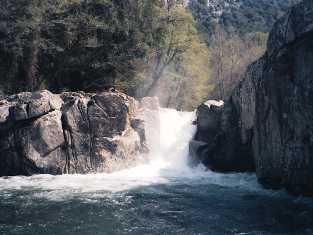
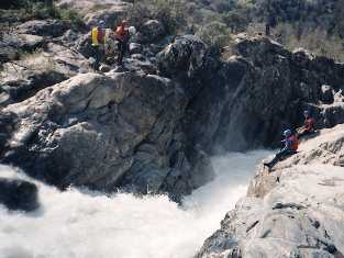
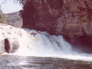
A wide sloping 6 metre ledge marks the start of the real fun. 100 metres below this is a 2-3 metre drop, and it is best to recce this and the succeeding 10 metre drop at the same time. A path on the left bank leads to a place where it is possible to scramble down to a water level platform near the exit of the big drop pool. This platform and beach is good for photographs and portages, although a bit distant from the fall for throw bag support
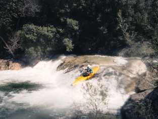
Shoot the 2 metre fall on the right at speed. The stopper is powerful. The route over the lip of the 10 metre fall is normally over the shallow patch on the extreme right, close to the rock wall. The aim is to to avoid the bottom stopper, and a suspected rock to the left in the plunge pool. The drop pool is exitedby a further 2 metre drop, normally taken on the extreme left.
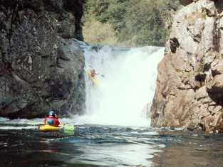 |
Upper Rizzanese - the big drop. Take it on the extreme right, to avoid rocks in the centre and river left in the plunge pool. |
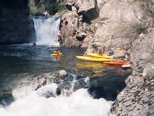 |
Same view - wider frame. The portage path bypassing the fall goes along the river left bank at a high level, and then clambers down to river level immediately above where the boats are tied up. |
Below this the river begins to ease off, but there are still two falls
to note. Firstly a simple looking 2 metre drop which washes onto a deeply
undercut rock below and to the right. Secondly a 6 metre drop into a very
boily pool which is very reluctant to give up swimmers. In the last three
years it has released one dead body and one swimmer alive but unconcious.
There is a sloping chicken chute to the right which is much more fun and
less nerve wracking.
| MIDDLE RIZZANESE | |
|---|---|
| From | Footpath near N 194 |
| To | D 69 Road Bridge |
| Grade | 3 |
| Length | 8km |
It is possible to get to the road from near the 6 metre drop, point
by carrying up a footpath on the right bank to the N194. But it is often
best to paddle the 8km of grade 3 river to the bridge on the D69 below
Arbellara. This provides a much less strenuous carry and a shorter drive.
This stretch of river is especially pleasant, and is worth paddling in
it's own right if the rigours of the upper Rizzanese are not wanted. Simple
rapids and a few broken weirs enliven a pleasant run through a scenic wooded
valley. There is a campsite close to the exit bridge.
| LOWER RIZZANESE | |
|---|---|
| From | D 69 Road Bridge |
| To | The Sea |
| Grade | 2 |
| Length | 14 km |
On the East coast of Corsica, many of the grade 2 touring rivers run through flat sedimentary landscapes, and are not especially attractive when compared to the scenery of the mountainous areas further upstream.. On the West coast however, the lower stretches of most of the rivers are much more attractive, although these easier stretches are often quite short.
The Rizzanese does provide one of the longer and more attractive of the grade 2 stretches on the island. A total length of 14 kilometres of river can be paddled, starting at the D69 road bridge. If a longer journey is wanted then a continuation round the coast into Propriano harbour is easily planned. For some reason completing a river trip at it's meeting with the sea always adds an indefineable sense of satisfaction to the day.