|
Corsica River Guide |
|
Corsica River Guide |
The Tavignano family provides a superb range of different paddling experiences in one (mostly) easily accessible river system - anything from relaxing grade three cruising to relentless, high grade expedition paddling. It's major tributary, the Vecchio, must be one of the best rivers in Corsica, providing three classic river trips of differing grades in only 20 kilometers of valley. Good things often come in small sizes.
The Tavignano, like the Golo, starts high in the mountains in the north west of the island. For over one third of it's length the river is not touched by road or track. Unless you fancy carrying your canoe or hiring mules the only way to enjoy the river is to don a pair of walking boots. This is a pity as the river is presumably similar to the neighbouring Restonica, which is well worth a visit. In my time in Corsica I did not fancy the walk, so the Tavignano guide starts where the river is accessible by road, in the mountain town of Corte
Corte provides a good base for most of these rivers, and it is itself a very pleasant place to spend a few restful hours in a bar or pavement cafe. Corte also has a rail station which gets you onto the mountain railway to Ajaccio - and peering down from a rail carriage is one of the few convenient ways of recceing the Upper Vecchio river.
| CORTE TOWN | One of the things I like about Corsica is the "frontier town" feeling, or bandit quality you get in some of the towns and villages. For example, one Easter morning we were sat in a pavement cafe in Corte, and suddenly the local male populace pulled out a huge selection of firearms - mainly shot guns, but rifles and pistols as well - and spent twenty very noisy minutes discharging them into the air. I have never found out why. Was it a political protest, or a sign of Christian penance before the Holy week? |
|---|---|
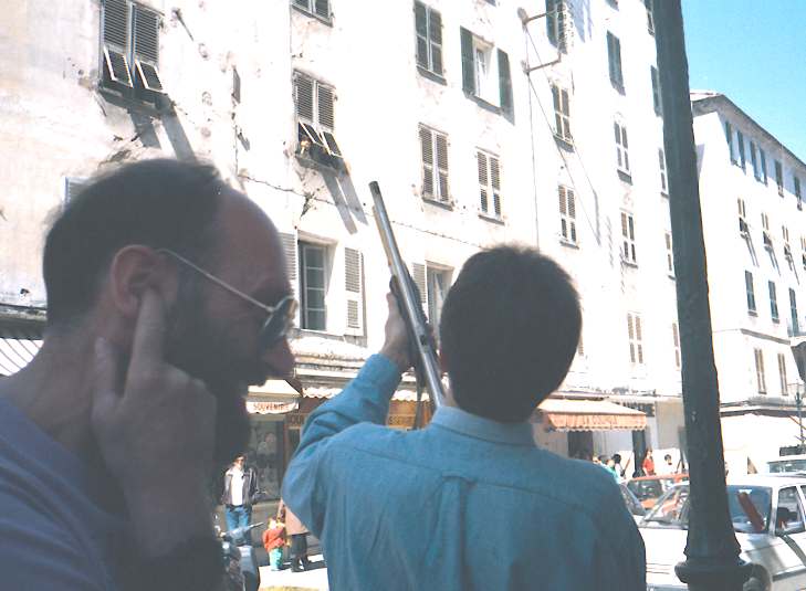
| Fred Wondre and a local resident (celebrating Easter???). There are some more of his friends under the awning on the far side of the road. |
| The shellcasings on the ground throughout Corte - showing how much lead went into the air. | 
|
There is a campsite near the town on the road up the Restonica valley. Wild camping and another campsite are available further up the Restonica valley, but this is not recommended at Easter as the steep valley sides cut out the sun and make for very cold mornings.
(In this guide it is easiest to describe the Vecchio in reverse order, starting with the lower sections then working upstream.)
| UPPER TAVIGNANO | |
|---|---|
| From | Corte |
| To | Pont de Piedicorte |
| Grade | 3(4) |
| Length | 25 km |
The river becomes approachable as it runs through the high mountain town of Corte. A few tracks and paths allow access to the river, and it can be paddled through the town if the river levels are high enough.
Once below the town, and the Restonica confluence, the river eases off to become like the Golo, a long meandering but scenic grade 3. The water is probably slightly less exciting than the Golo, but the scenery more rural and pleasant. The river enters a small gorge section just above the Vecchio confluence, raising the grade level to an easy 4.
The only major tributary to join the Tavignano is the Vecchio, which can add almost as much water as the Tavignano carries, to produce a more exciting and powerful river below the confluence.
| TAVIGNANO GORGE | |
|---|---|
| From | Pont de Piedocorte |
| To | Faio |
| Grade | 3-4 |
| Length | 18 km |
By far the best part of the Tavignano is the gorge north west of the small hamlet of Faio. Access is easiest through an olive grove upstream of the gorge, close to the Pont de Piedicorte. Normally this is clearly marked from the road by a mass of canoeists tents and cars. Camping is possible here, but is not reccomended for those wanting solitude.
The gorge itself is long, narrow and steep sided. It approaches grade 4 in parts, but normally runs at grade 2-3. The interest comes mainly from the shape and structure of the river. In places a paddler with 208 centimetre paddles could easily get them trapped across the gorge walls. Although not difficult or especially tricky, the lack of places to land once in the gorge makes it quite a serious trip.
An old bridge across the gorge marks the end of the fun. A water level gauge is situated here, downstream of the succeeding new bridge on the river right. This needs about 150 centimetres or higher for ideal conditions, equating to about 160 centimetres at the Vecchio gauge at the Noceta road bridge, which is much easier to read. The easiest exit is to carry on for about 500 metres to the next modern road bridge. Exit on the left below the bridge, and follow a gently sloping path leading up the bank away from the bridge. This comes out at the obvious lay-by on the N200 about 200 yards east of the bridge.
| LOWER TAVIGNANO | |
|---|---|
| From | Faio |
| To | The Sea |
| Grade | 1-2 |
| Length | 18 km |
Once leaving the lower Taravo gorge, the river runs into the flatter sedimentary lowlands of the eastern plains. Apart from the occassional shallows the river is calm but fast flowing.
| RESTONICA | |
|---|---|
| From | Optional |
| To | Optional |
| Grade | 6-7 ??? |
| Length | Optional |
On a sunny day, the Restonica valley is one of the most impressive sights in Corsica. Unfortunately it is also the most easily accessible of Corsica's high valleys, leading to a stream of coaches, cars and mountain bikes passing up and down the road.
If the river levels are low it is no bad thing to join them. An evening drive to the head of the valley will never be wasted, especially with a bike on the roof-rack to coast back down to Corte. There is a campsite halfway up the valley which is especially scenic, although cold in the mornings as the sun is hidden by the towering sky line.
For many canoeists a visit to the Restonica will only be by car, as the narrow catchment is less likely to provide canoeable water than many of it's bigger neighbours. But if the river is flowing it provides one of the steepest gradients easily available in Corsica. It is possible to recce almost all of the river from the road, and to select the bit to be paddled depending on the water level. The highest start point is normally near the grotto about 14 kilometres above Corte, where a track leads down to the river. There is no reason why higher sections could not be attempted if water levels allow.
The river itself contains an endless succession of steep drops into narrow pools in a tight, overgrown slash of a gorge. Take your oldest paddles and equipment, and allow about 90 minutes per kilometre. It has a character that either appeals or repels you, depending on whether you like dropping over a 3 metre ledge whilst trying to avoid hitting your head on the fallen tree half way down, and then back-paddling immediately on landing to avoid a gorse thicket. (Or perhaps I could be biased against the river, having picked the wrong section to paddle).
High up in the valley the river valley is open, running at about grade 5-6, but overgrown. As the river descends it slowly closes in to a shallow gorge, with the obstacles becoming more mineral and less vegetable. As if to compensate the river grade goes up to 6 or 7. The river only eases very close to the town itself, running through Corte to the Tavignano at about grade 4.
| LOWER VECCHIO | |
|---|---|
| From | Noceta Road Bridge |
| To | Confluence with Tavignano |
| Grade | 3-4 |
| Length | 4 km (plus 3 km on Tavignano) |
The lowest section of the Vecchio runs from the bridge over the D43 (leading to Noceta) down to the Tavignano. A gauge here is used to give the river levels described for all three sections of the river. When I paddled the river at a level of 170 centimetres it was a good fast bouncy grade 3-4. It could probably be paddled at grade 3 at levels as low as 140.
The best exit point is the D200 bridge over the Tavignano shortly after the confluence. If there has been a lot of rain and the more difficult rivers are washed out, then the lower Vecchio followed by the Tavignano gorge may be a good option for an interesting days paddle.
| MIDDLE VECCHIO | |
|---|---|
| From | N 193 Road Bridge |
| To | Noceta Road Bridge (D43) |
| Grade | 5 (6) |
| Length | 8 km |
As well as being good water in it's own right, the middle Vecchio provides a useful test piece for Corsican canoeing. Although difficult, running at grade 5 (occasionally 6) for much of it's length, it is user friendly. It is easily scouted (or portaged), has a few tricky falls, and access back to the road is not too difficult. If your group is not too experienced in Corsica, and wishes to work out whether you will cope with the more committing rivers such as the Travo and Rizzanese, then run the middle Vecchio. If you can run this at a level of between 150 and 170 (although probably with a few portages) and work well as a group with no problems, then you should cope with most rivers on the island.
The middle Vecchio starts close to the high road bridge on the N193 north of Vivario. Park in the layby on the south bank (about 100 metres away from the bridge) and look for the track leading down to the river. At the level mentioned above the river is mostly grade 5, easing towards the end. It runs at an easy grade 5 at 140 centimetres, and is probably not worth paddling below that level.
| UPPER VECCHIO | |
|---|---|
| From | Canaglio |
| To | N 193 Road Bridge |
| Grade | 7-8 |
| Length | 8 km |
If the middle Vecchio is a test piece for the average Corsican paddler, then the upper Vecchio is the test piece for the true Corsican hard man. For my first time I was lucky enough to be escorted down it in low water by an experienced German paddler. That was difficult enough. Paddling this river at a good level without a guide would be quite a challenge. For a first descent, unless you are guided, I would reccomend no more than 150 centimetres on the Noceta gauge.
The river can be partly recced in two ways. The D723 leading away from the north end of the high bridge over the Vecchio gives a view up the lower stretch of this section. Secondly the railway line running from Corte to Bastia passes up the valley and gives a clear view. The relevant stretch is reached by walking up the line from Vivario station. A good recce is strongly reccomended in order to get a clear image of the valley's geography in your mind before attempting the river.
The access point is reached by turning off the N193 south of Vivario close to Tattone rail station. Follow the road winding north around the ridge, then down to a bridge over the Vecchio. Although the Manganello (a tributary) is the larger of the two rivers in this valley, access to it near Canaglio is through private farm land and not easy.
The river in the early stages is reasonably open, especially after the Manganello joins, with falls through boulder fields or over long series of ledges (seePicture). Recconaissance is fairly straight forward, and portages not too frequent. The biggest problem in this section is that some of the plunge pools are quite shallow. Check them carefully and be prepared to take a few hard landings and a risk of pinning. At a gauge level of 150 centimetres this section runs at grade 6-7 .
A sharp left hand bend with the railway line in sight high up to the right gives a clear warning of a 13 metre waterfall situated just round the corner. Now is the time to take stock. This point is slightly over half way down the gorge in distance, but less than halfway in time or difficulty. Do you want to evacuate now if time is running out and dusk approaching, or if the river is proving too tricky? Do not be ashamed if you do. 2 days is not an unusual time for a full first descent of 8 kilometres of the upper Vecchio. Some groups have taken two days to get only this far. The way out is a strenuous scramble up the scree slope to the railway, then follow it to Vivario. Be careful on the loose scree.
After portaging the waterfall the descent continues. The 400 metres immediately below the waterfall are very tight and tricky, with an especially narrow gorge section (seePicture) and nasty undercut fall just before the river bends round to the right. After the bend the river opens out again to produce an amazingly jumbled boulder fall section. Most of this part of the gorge runs at grade 7-8 unless the water is low. Many paddlers will have four or five portages, some involving crossing and recrossing the river before a canoeable section can be reached again. The interminable progress of recce, bank support, carry and paddle will seem endless, and you will look in vain for any glimpse of the end of the section. Finally, around the final bend, the high bridge appears. But this is not the time to relax, as the steepness of the river continues right up to the stanchions of the bridge.
The final portage, carrying heavy canoes up the steep bank to the road, will seem the hardest one of all. For the first time in hours (or days) physical activity will not be supported by surges of adrenalin, and you will suddenly realise how tired you are. But who cares? You have canoed one of the hardest and best of the rivers of Corsica.